
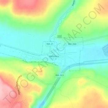
Carte topographique Kahlotus
Carte interactive
Cliquez sur la carte pour afficher l’altitude.
À propos de cette carte
Nom : Carte topographique Kahlotus, altitude, relief.
Altitude moyenne : 327 m
Altitude minimum : 259 m
Altitude maximum : 433 m
Being located on the floor of a coulee puts Kahlotus at relatively lower elevation than the surrounding terrain. The steep walls of the coulee rise hundreds of feet dramatically to the north and south of the city center.
Autres cartes topographiques
Cliquez sur une carte pour visualiser sa topographie, son altitude et son relief.
Farrington
United States > Washington > Franklin County
Farrington, Franklin County, Washington, United States
Altitude moyenne : 294 m
Harder
United States > Washington > Franklin County
Harder, Franklin County, Washington, United States
Altitude moyenne : 350 m
West Pasco
United States > Washington > Franklin County
West Pasco, Franklin County, Washington, United States
Altitude moyenne : 119 m
Lower Monumental Dam
United States > Washington > Franklin County
Lower Monumental Dam, Franklin County, Washington, United States
Altitude moyenne : 230 m
Basin City
United States > Washington > Franklin County
Basin City, Franklin County, Washington, 99343, United States
Altitude moyenne : 221 m
Connell
United States > Washington > Franklin County
Connell, Franklin County, Washington, 99326, United States
Altitude moyenne : 312 m
Mesa
United States > Washington > Franklin County
Mesa, Franklin County, Washington, United States
Altitude moyenne : 239 m
Eltopia
United States > Washington > Franklin County
Eltopia, Franklin County, Washington, United States
Altitude moyenne : 211 m
Pasco
United States > Washington > Franklin County
Pasco, Franklin County, Washington, 99301, United States
Altitude moyenne : 141 m
Pasco
United States > Washington > Franklin County > Pasco
Pasco, Franklin County, Washington, United States
Altitude moyenne : 165 m