
Carte topographique Rother
Carte interactive
Cliquez sur la carte pour afficher l’altitude.
À propos de cette carte
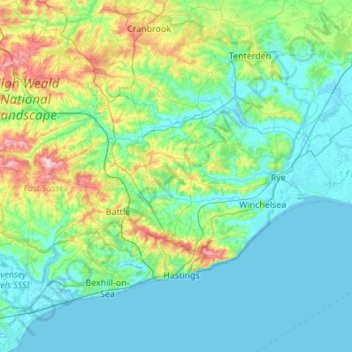
Nom : Carte topographique Rother, altitude, relief.
Lieu : Rother, East Sussex, South East, Engeland, VK (50.81931 0.32156 51.08365 0.86786)
Altitude moyenne : 36 m
Altitude minimum : -2 m
Altitude maximum : 193 m
Autres cartes topographiques
Cliquez sur une carte pour visualiser sa topographie, son altitude et son relief.
Tillingham
Tillingham, Rother, East Sussex, South East, Engeland, TN31 6ET, VK
Altitude moyenne : 39 m