
Carte topographique Hermanus
Carte interactive
Cliquez sur la carte pour afficher l’altitude.
À propos de cette carte
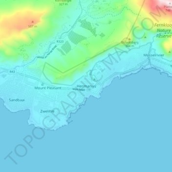
Nom : Carte topographique Hermanus, altitude, relief.
Altitude moyenne : 87 m
Altitude minimum : -1 m
Altitude maximum : 743 m
Autres cartes topographiques
Cliquez sur une carte pour visualiser sa topographie, son altitude et son relief.
Gansbaai
South Africa > Western Cape > Overstrand Local Municipality
Gansbaai, Overstrand Local Municipality, Western Cape, South Africa
Altitude moyenne : 34 m
Onrus River
South Africa > Western Cape > Overstrand Local Municipality
Onrus River, Overstrand Local Municipality, Western Cape, South Africa
Altitude moyenne : 232 m
Betty's Bay
South Africa > Western Cape > Overstrand Local Municipality
Betty's Bay, Overstrand Local Municipality, Western Cape, 7141, South Africa
Altitude moyenne : 210 m
Stanford
South Africa > Western Cape > Overstrand Local Municipality
Stanford, Overstrand Local Municipality, Western Cape, 7210, South Africa
Altitude moyenne : 107 m
Boskop
South Africa > Western Cape > Overstrand Local Municipality
Boskop, Overstrand Local Municipality, Overberg District Municipality, Western Cape, 7210, South Africa
Altitude moyenne : 503 m
Three Sisters
South Africa > Western Cape > Overstrand Local Municipality
Three Sisters, Overstrand Local Municipality, Overberg District Municipality, Western Cape, 7195, South Africa
Altitude moyenne : 306 m
Kleinmond
South Africa > Western Cape > Overstrand Local Municipality
Kleinmond, Overstrand Local Municipality, Western Cape, 7195, South Africa
Altitude moyenne : 119 m