
Carte topographique Middle Fork Salmon River
Carte interactive
Cliquez sur la carte pour afficher l’altitude.
À propos de cette carte
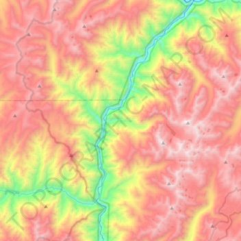
Nom : Carte topographique Middle Fork Salmon River, altitude, relief.
Altitude moyenne : 2 092 m
Altitude minimum : 924 m
Altitude maximum : 3 067 m
The Middle Fork is a heavily whitewatered 104-mile-long (167 km) tributary of the Salmon River, the main tributary of the Snake River, which in turn is the main tributary to the Columbia River. The nearest town is Stanley, Idaho. The Middle Fork's elevation starts at 7,000 feet (2,100 m) above sea level and drops down to 3,015 feet (919 m)at its mouth. The 47 mile long Bear Valley Creek and Marsh Creek converge to form the Middle Fork. The Middle Fork has around a hundred tributaries; some of the larger are Rapid River, Loon Creek and Camas Creek, all from 20 to 25 miles (32 to 40 km) long. The Middle Fork flows through 2,500 square miles (6,500 km2) of rugged terrain known as the Salmon River Mountains, peaks of which reach 10,000 feet (3,000 m).
Autres cartes topographiques
Cliquez sur une carte pour visualiser sa topographie, son altitude et son relief.
Goat Lake
United States > Idaho > Lemhi County
Goat Lake, Lemhi County, Idaho, United States
Altitude moyenne : 2 590 m
Salmon
United States > Idaho > Lemhi County
Salmon, Lemhi County, Idaho, 83467, United States
Altitude moyenne : 1 247 m