
Carte topographique Cuauhtémoc
Carte interactive
Cliquez sur la carte pour afficher l’altitude.
À propos de cette carte
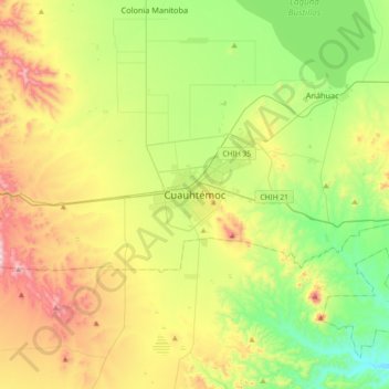
Nom : Carte topographique Cuauhtémoc, altitude, relief.
Lieu : Cuauhtémoc, Chihuahua, 31500, Mexico (28.24096 -107.02653 28.56096 -106.70653)
Altitude moyenne : 2 073 m
Altitude minimum : 1 771 m
Altitude maximum : 2 591 m
Cuauhtémoc has a semi-arid climate (Köppen climate classification BSk) moderated by its altitude. Winter days are cool and sunny with a January high of 15.6 °C (60.1 °F), while winter nights are cold with temperatures usually below freezing. The city usually sees 1 or 2 snowfalls per year. Summers are warm with June being the warmest month with an average high temperature of 29.5 °C (85.1 °F). Most of the precipitation falls during this time of the year, during the monsoon season. The highest recorded temperature was 40.0 °C (104.0 °F) on June 9, 1995 while the lowest recorded temperature was −18 °C (−0.4 °F) on December 30, 1975.