
Carte topographique Lewis County
Carte interactive
Cliquez sur la carte pour afficher l’altitude.
À propos de cette carte
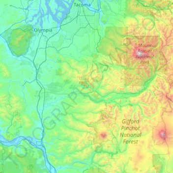
Nom : Carte topographique Lewis County, altitude, relief.
Lieu : Lewis County, Washington, United States of America (46.38127 -123.37090 46.79445 -121.35268)
Altitude moyenne : 558 m
Altitude minimum : -3 m
Altitude maximum : 4 320 m
Autres cartes topographiques
Cliquez sur une carte pour visualiser sa topographie, son altitude et son relief.
Lake Morton-Berrydale
United States of America > Washington > Lake Morton-Berrydale
Lake Morton-Berrydale, King County, Washington, United States of America
Altitude moyenne : 132 m
Redmond
United States of America > Washington > Redmond
Redmond, King County, Washington, United States of America
Altitude moyenne : 72 m
Okanogan County
United States of America > Washington > Okanogan County
Okanogan County, Washington, United States of America
Altitude moyenne : 1 076 m
Yakima County
United States of America > Washington
Yakima County, Washington, United States of America
Altitude moyenne : 879 m
Clallam County
United States of America > Washington
Clallam County, Washington, United States of America
Altitude moyenne : 335 m
Island County
United States of America > Washington
Island County, Washington, United States of America
Altitude moyenne : 98 m