
Carte topographique Ciénaga de Zapata
Carte interactive
Cliquez sur la carte pour afficher l’altitude.
Ciénaga de Zapata
The Zapata Swamp lies between 22°01’ and 22°40’ N latitude and between 80°33’ and 82°09’ W longitude. The swamp in total is over one million acres (4,000 km²). Topographically, the maximum height above sea level is only about 10 meters with the top depth in below-sea-level coastal zones as follows: 2 meters in the salt-marsh area and from 1–600 meters in the sea coastal zone. Between May and October, the warmest season of the year, average temperature is 30 °C (86 °F). Between November and April, the coldest season of the year, the temperature on average is 20 °C (68 °F).
À propos de cette carte
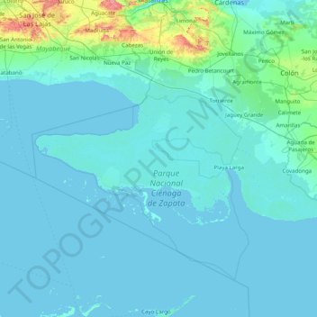
Nom : Carte topographique Ciénaga de Zapata, altitude, relief.
Lieu : Ciénaga de Zapata, Matanzas, Cuba (22.03770 -82.15773 22.61128 -80.59372)
Altitude moyenne : 18 m
Altitude minimum : -2 m
Altitude maximum : 354 m
Autres cartes topographiques
Cliquez sur une carte pour visualiser sa topographie, son altitude et son relief.