
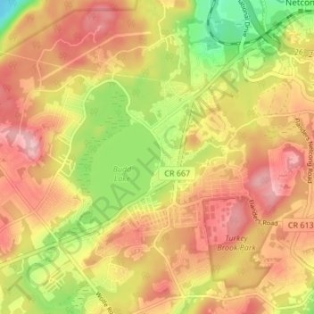
Carte topographique Budd Lake
Carte interactive
Cliquez sur la carte pour afficher l’altitude.
À propos de cette carte
Nom : Carte topographique Budd Lake, altitude, relief.
Altitude moyenne : 313 m
Altitude minimum : 223 m
Altitude maximum : 378 m
Budd Lake, which the community is named after, is the source of the South Branch Raritan River. A glacial lake at an elevation of 933 feet (284 m), Budd Lake has a surface area of 374 acres (1.51 km2). It is 7–12 feet deep, and can have large algal blooms. The bog, created by thousands of years of decaying plant material, supports wetland plants such as black spruce and tamarack, which grow on the floating mass. The lake is recharged through groundwater seepage through a series of wetlands, and serves as the headwaters of the Raritan River's South Branch. It is closely bordered by U.S. Route 46 to the south, and Sand Shore Road to the east.
Autres cartes topographiques
Cliquez sur une carte pour visualiser sa topographie, son altitude et son relief.
Bartley
United States > New Jersey > Morris County > Mount Olive
Bartley, Mount Olive, Morris County, New Jersey, 07836, United States
Altitude moyenne : 231 m
Flanders
United States > New Jersey > Morris County > Mount Olive
Flanders, Mount Olive, Morris County, New Jersey, 07836, United States
Altitude moyenne : 255 m