
Carte topographique Manorhamilton Municipal District
Carte interactive
Cliquez sur la carte pour afficher l’altitude.
À propos de cette carte
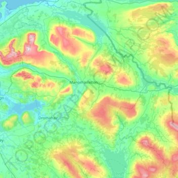
Nom : Carte topographique Manorhamilton Municipal District, altitude, relief.
Altitude moyenne : 156 m
Altitude minimum : -1 m
Altitude maximum : 641 m
Autres cartes topographiques
Cliquez sur une carte pour visualiser sa topographie, son altitude et son relief.
Acres
Acres, Aghavas ED, Ballinamore Municipal District, County Leitrim, Connacht, Ireland
Altitude moyenne : 74 m
Keshcarrigan
Keshcarrigan, Ballinamore Municipal District, County Leitrim, Connacht, Ireland
Altitude moyenne : 78 m
Blackmountain
Blackmountain, Munakill ED, Manorhamilton Municipal District, County Leitrim, Connacht, Ireland
Altitude moyenne : 234 m
Ballinamore Municipal District
Ballinamore Municipal District, County Leitrim, Connacht, Ireland
Altitude moyenne : 109 m
Moher (Gregg)
Moher (Gregg), Moher ED, Ballinamore Municipal District, County Leitrim, Connacht, Ireland
Altitude moyenne : 233 m