
Carte topographique Santa Cruz
Carte interactive
Cliquez sur la carte pour afficher l’altitude.
À propos de cette carte
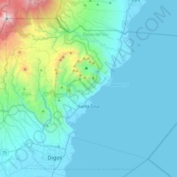
Nom : Carte topographique Santa Cruz, altitude, relief.
Lieu : Santa Cruz, Davao del Sur, Davao Region, 8001, Philippines (6.74155 125.27078 6.98719 125.58180)
Altitude moyenne : 360 m
Altitude minimum : -4 m
Altitude maximum : 2 923 m
Santa Cruz is traversed by mountain ranges and high relief that include part of Mount Apo, the highest mountain peak in the Philippines, straddle the south, central, north and north-western portions of the municipality. The rugged topography of the central area gradually undulates toward the coastal plains of the north-eastern, eastern and south-eastern parts. Here, settlements sprawl contiguously along the coast of Davao Gulf under the vast monotony of coconut plantations. On the western frontier, a plateau stretches toward Barangay Kapatagan of Digos. The municipal elevation ranges from 10 to 2,939 metres (33 to 9,642 ft) above sea level (m.a.s.1.).
Autres cartes topographiques
Cliquez sur une carte pour visualiser sa topographie, son altitude et son relief.
Digos
Philippines > Davao del Sur > Digos
Digos, Davao del Sur, Davao Region, 8002, Philippines
Altitude moyenne : 152 m
Digos
Digos, Davao del Sur, Davao Region, 8002, Philippines
Altitude moyenne : 499 m
Bansalan
Philippines > Davao del Sur > Bansalan
Bansalan, Davao del Sur, Davao Region, 8005, Philippines
Altitude moyenne : 157 m
Soong
Philippines > Davao del Sur > Digos > Soong
Soong, Digos, Davao del Sur, Davao Region, 8002, Philippines
Altitude moyenne : 280 m
Mount Apo
Philippines > Davao del Sur > Bansalan
Mount Apo, Bansalan, Davao del Sur, Davao Region, 8005, Philippines
Altitude moyenne : 2 416 m
Davao del Sur
Davao del Sur, Davao Region, Philippines
Altitude moyenne : 116 m