
Carte topographique Pfronten
Carte interactive
Cliquez sur la carte pour afficher l’altitude.
À propos de cette carte
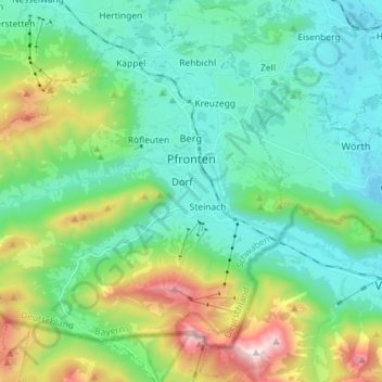
Nom : Carte topographique Pfronten, altitude, relief.
Lieu : Pfronten, Landkreis Ostallgäu, Bavaria, 87459, Germany (47.53347 10.45444 47.61300 10.59792)
Altitude moyenne : 1 085 m
Altitude minimum : 787 m
Altitude maximum : 1 985 m
Pfronten is located on the northern edge of the Allgäu Alps. The Vils flows through the municipal territory. It is situated at an altitude of 853 m above sea level. NN at the foot of Edelsberg, Kienberg, Breitenberg and Falkenstein. The highest point of the municipality is the summit of the Aggenstein (1986 m above sea level) on the Tyrolean border, which belongs to the Tannheim Mountains.
Autres cartes topographiques
Cliquez sur une carte pour visualiser sa topographie, son altitude et son relief.
Untergermaringen
Germany > Bavaria > Landkreis Ostallgäu
Untergermaringen, Germaringen, Landkreis Ostallgäu, Bavaria, 87656, Germany
Altitude moyenne : 674 m