
Carte topographique Anshan City
Carte interactive
Cliquez sur la carte pour afficher l’altitude.
Anshan City
Local transportation is primarily by bus or taxi. Anshan used to have a single tram line—along Zhonghua Avenue, through the city centre and past Angang main gate—but this has been closed and the tracks removed. Due to the flat topography of the city centre, bicycles are popular. Almost all roads have a wide cycle lane on each side. Often this lane is further protected by a traffic island that separates the bikes from larger motor vehicles.
À propos de cette carte
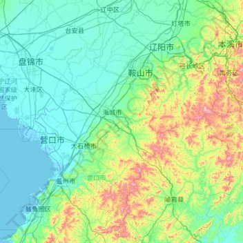
Nom : Carte topographique Anshan City, altitude, relief.
Lieu : Anshan City, Liaoning, China (39.99865 122.18702 41.56818 123.76188)
Altitude moyenne : 145 m
Altitude minimum : -2 m
Altitude maximum : 1 111 m
Autres cartes topographiques
Cliquez sur une carte pour visualiser sa topographie, son altitude et son relief.
Anshan
Local transportation is primarily by bus or taxi. Anshan used to have a single tram line—along Zhonghua Avenue, through the city centre and past Angang main gate—but this has been closed and the tracks removed. Due to the flat topography of the city centre, bicycles are popular. Almost all roads have a…
Altitude moyenne : 79 m