
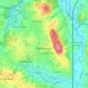
Carte topographique Hiddenhausen
Carte interactive
Cliquez sur la carte pour afficher l’altitude.
À propos de cette carte
Nom : Carte topographique Hiddenhausen, altitude, relief.
Altitude moyenne : 92 m
Altitude minimum : 55 m
Altitude maximum : 173 m
Autres cartes topographiques
Cliquez sur une carte pour visualiser sa topographie, son altitude et son relief.
Vlotho
Duitsland > Noordrijn-Westfalen > Kreis Herford
Vlotho, Kreis Herford, Noordrijn-Westfalen, 32602, Duitsland
Altitude moyenne : 149 m
Kirchlengern
Duitsland > Noordrijn-Westfalen > Kreis Herford
Kirchlengern, Kreis Herford, Noordrijn-Westfalen, Duitsland
Altitude moyenne : 80 m
Bonneberg
Duitsland > Noordrijn-Westfalen > Kreis Herford > Vlotho > Bonneberg
Bonneberg, Vlotho, Kreis Herford, Noordrijn-Westfalen, 32602, Duitsland
Altitude moyenne : 150 m
Löhne
Duitsland > Noordrijn-Westfalen > Kreis Herford
Löhne, Kreis Herford, Noordrijn-Westfalen, 32584, Duitsland
Altitude moyenne : 93 m
Vlotho
Duitsland > Noordrijn-Westfalen > Kreis Herford > Vlotho
Vlotho, Kreis Herford, Noordrijn-Westfalen, 32602, Duitsland
Altitude moyenne : 119 m
Herford-Stadt
Duitsland > Noordrijn-Westfalen > Kreis Herford
Herford-Stadt, Herford, Kreis Herford, Noordrijn-Westfalen, Duitsland
Altitude moyenne : 91 m