
Carte topographique Hudson Glacier
Carte interactive
Cliquez sur la carte pour afficher l’altitude.
À propos de cette carte
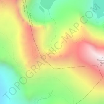
Nom : Carte topographique Hudson Glacier, altitude, relief.
Altitude moyenne : 2 079 m
Altitude minimum : 1 411 m
Altitude maximum : 2 853 m
Autres cartes topographiques
Cliquez sur une carte pour visualiser sa topographie, son altitude et son relief.
Herbst Glacier
USA > Montana > Wurtz Hill
Herbst Glacier, Boulder Pass, Wurtz Hill, Flathead County, Montana, USA
Altitude moyenne : 2 019 m
Kintla Glacier
USA > Montana > Wurtz Hill
Kintla Glacier, Boulder Pass, Wurtz Hill, Flathead County, Montana, USA
Altitude moyenne : 2 336 m
Agassiz Glacier
USA > Montana > Wurtz Hill
Agassiz Glacier, Boulder Pass, Wurtz Hill, Flathead County, Montana, USA
Altitude moyenne : 2 376 m
Dixon Glacier
USA > Montana > Wurtz Hill
Dixon Glacier, Boulder Pass, Wurtz Hill, Flathead County, Montana, USA
Altitude moyenne : 2 192 m
Harris Glacier
USA > Montana > Wurtz Hill
Harris Glacier, Boulder Pass, Wurtz Hill, Flathead County, Montana, USA
Altitude moyenne : 2 138 m
Boulder Glacier
USA > Montana > Wurtz Hill
Boulder Glacier, Boulder Pass, Wurtz Hill, Flathead County, Montana, USA
Altitude moyenne : 2 105 m
Thunderbird Glacier
USA > Montana > Wurtz Hill
Thunderbird Glacier, Boulder Pass, Wurtz Hill, Flathead County, Montana, USA
Altitude moyenne : 2 162 m