
Carte topographique Nyaruguru
Carte interactive
Cliquez sur la carte pour afficher l’altitude.
À propos de cette carte
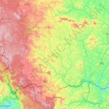
Nom : Carte topographique Nyaruguru, altitude, relief.
Lieu : Nyaruguru, Southern Province, Rwanda (-2.83898 29.32765 -2.53124 29.74740)
Altitude moyenne : 1 991 m
Altitude minimum : 1 377 m
Altitude maximum : 2 738 m
Autres cartes topographiques
Cliquez sur une carte pour visualiser sa topographie, son altitude et son relief.
Rubona
Rwanda > Southern Province > Huye > Rusatira
Rubona, Rusatira, Huye, Southern Province, Rwanda
Altitude moyenne : 1 635 m
Kibeho
Rwanda > Southern Province > Nyaruguru District
Kibeho, Nyaruguru District, Southern Province, Rwanda
Altitude moyenne : 1 876 m
Gatare
Rwanda > Southern Province > Nyamagabe
Gatare, Nyamagabe, Southern Province, Rwanda
Altitude moyenne : 2 185 m
Rubyiro
Rwanda > Southern Province > Nyamagabe > Buruhukiro
Rubyiro, Buruhukiro, Nyamagabe, Southern Province, Rwanda
Altitude moyenne : 2 413 m
Mbuye
Rwanda > Southern Province > Ruhango
Mbuye, Ruhango, Southern Province, Rwanda
Altitude moyenne : 1 589 m
Huye
Rwanda > Southern Province > Huye > Ngoma
Huye, Ngoma, Huye, Southern Province, Rwanda
Altitude moyenne : 1 665 m
Nyaruguru
Rwanda > Southern Province > Nyaruguru District > Munini
Nyaruguru, Munini, Nyaruguru District, Southern Province, Rwanda
Altitude moyenne : 1 892 m
Kigoma
Rwanda > Southern Province > Kigoma
Kigoma, Huye, Southern Province, Rwanda
Altitude moyenne : 1 719 m