
Carte topographique Patterson Park
Carte interactive
Cliquez sur la carte pour afficher l’altitude.
À propos de cette carte
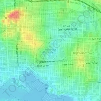
Nom : Carte topographique Patterson Park, altitude, relief.
Altitude moyenne : 17 m
Altitude minimum : -3 m
Altitude maximum : 55 m
Autres cartes topographiques
Cliquez sur une carte pour visualiser sa topographie, son altitude et son relief.
Gwynns Falls Leakin Park
Gwynns Falls Leakin Park, Wakefield, Baltimore, Maryland, USA
Altitude moyenne : 98 m
Cylburn Arboretum
Cylburn Arboretum, Cold Spring, Baltimore, Maryland, USA
Altitude moyenne : 104 m
Prospect Hill
Prospect Hill, Baltimore, Maryland, 21211, USA
Altitude moyenne : 85 m