
Faire un don
Équipez-vous pour votre prochaine aventure :
En tant que Partenaire Amazon, ce site perçoit une commission sur les achats éligibles sans surcoût pour vous.
Carte topographique Pratapgarh
Cliquez sur la carte pour afficher l’altitude.
Faire un don
Équipez-vous pour votre prochaine aventure :
En tant que Partenaire Amazon, ce site perçoit une commission sur les achats éligibles sans surcoût pour vous.
Pratapgarh
Pratapgarh District is a newly constituted district in Rajasthan state. it came into existence on 26 January 2008, as the 33rd district of Rajasthan. Pratapgarh is located at 24.03° N 74.78° E. It has an average elevation of 491 metres (1610 feet). It is said to be the second highest place in Rajasthan after Mount Abu.
Faire un don
Équipez-vous pour votre prochaine aventure :
En tant que Partenaire Amazon, ce site perçoit une commission sur les achats éligibles sans surcoût pour vous.
À propos de cette carte
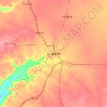
Nom : Carte topographique Pratapgarh, altitude, relief.
Altitude moyenne : 503 m
Altitude minimum : 428 m
Altitude maximum : 529 m
Faire un don
Équipez-vous pour votre prochaine aventure :
En tant que Partenaire Amazon, ce site perçoit une commission sur les achats éligibles sans surcoût pour vous.