
Carte topographique San Rafael
Carte interactive
Cliquez sur la carte pour afficher l’altitude.
À propos de cette carte
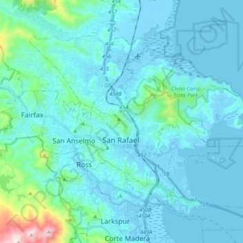
Nom : Carte topographique San Rafael, altitude, relief.
Altitude moyenne : 78 m
Altitude minimum : -6 m
Altitude maximum : 778 m
San Rafael has a wide diversity of natural habitats from forests at the higher elevations to marshland and estuarine settings. Its marshes are home to the endangered species Salt Marsh Harvest Mouse. There are also riparian areas including the San Rafael Creek and Miller Creek corridors.