
Carte topographique Capelas
Carte interactive
Cliquez sur la carte pour afficher l’altitude.
À propos de cette carte
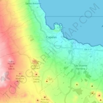
Nom : Carte topographique Capelas, altitude, relief.
Lieu : Capelas, Ponta Delgada, Azores, Portugal (37.80425 -25.75047 37.85171 -25.66940)
Altitude moyenne : 195 m
Altitude minimum : 0 m
Altitude maximum : 588 m
The first settlements congregated around the port of Poços, along the northern edge that divides Capelas from São Vicente Ferreira; its first settlers establishing shelters in and around the 16th Century. With elevation of Capelas to (religious) parish it became integrated within the municipality of Ponta Delgada (on 11 July 1592). This administrative dependency lasted until it was elevated to status of vila, as stipulated by the Carta de Lei (Charter Law) conferred by Queen D. Maria, on July 10, 1839.
Autres cartes topographiques
Cliquez sur une carte pour visualiser sa topographie, son altitude et son relief.
São Vicente Ferreira
Portugal > Ponta Delgada > São Vicente Ferreira
São Vicente Ferreira, Ponta Delgada, Azores, Portugal
Altitude moyenne : 152 m