
Carte topographique Lauterbach
Cliquez sur la carte pour afficher l’altitude.
À propos de cette carte
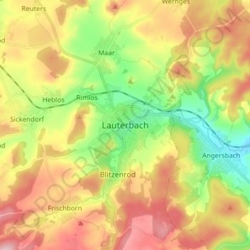
Nom : Carte topographique Lauterbach, altitude, relief.
Lieu : Lauterbach, Vogelsbergkreis, Hesse, 36341, Germany (50.59685 9.35686 50.67685 9.43686)
Altitude moyenne : 361 m
Altitude minimum : 251 m
Altitude maximum : 484 m
Autres cartes topographiques
Cliquez sur une carte pour visualiser sa topographie, son altitude et son relief.
Alsfeld
Germany > Hesse > Vogelsbergkreis
The Pfefferhöhe rest area near Alsfeld is the second highest rest area (in altitude) along the A 5, the and also a popular meeting place.
Altitude moyenne : 331 m