Géolocaliser

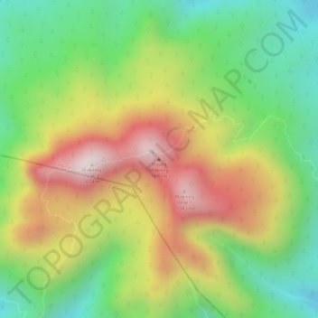
Carte topographique Mount Makiling

Cliquez sur la carte pour afficher l’altitude.

Mount Makiling

Mount Makiling (also spelled Maquiling) is an inactive stratovolcano located in the provinces of Laguna and Batangas on the island of Luzon in the Philippines. The mountain rises to an elevation of 1,090 meters (3,580 ft) above mean sea level and is the highest feature of the Laguna Volcanic Field. It is listed as a Stratovolcano of both the Laguna Volcanic Field and the separate Taal caldera by the Global Volcanism Program. The volcano has no recorded historic eruption but volcanism is still evident through geothermal features like mud spring and hot springs. South of the mountain is the Makiling–Banahaw Geothermal Plant. The Philippine Institute of Volcanology and Seismology (PHIVOLCS) classifies the volcano as "Inactive".

Wikipedia (CC-BY-SA 3.0)

À propos de cette carte

Nom : Carte topographique Mount Makiling, altitude, relief.

Lieu : Mount Makiling, Los Baños, Laguna, Calabarzon, 4030, Philippines (14.13517 121.19440 14.13527 121.19450)

Altitude moyenne : 753 m

Altitude minimum : 467 m

Altitude maximum : 1 076 m

Autres cartes topographiques

Cliquez sur une carte pour visualiser sa topographie, son altitude et son relief.
Maahas

Philippines > Laguna > Los Baños

Altitude moyenne : 17 m

Mount Makiling

Philippines > Laguna > Los Baños

Altitude moyenne : 327 m

Molawin Creek

Philippines > Laguna > Los Baños

Altitude moyenne : 16 m

Batong Malake

Philippines > Laguna > Los Baños

Altitude moyenne : 93 m

Putho Tuntungin

Philippines > Laguna > Los Baños

Altitude moyenne : 55 m

Lalakay

Philippines > Laguna > Los Baños

Altitude moyenne : 81 m

Bagong Silang

Philippines > Laguna > Los Baños

Altitude moyenne : 270 m

Tadlak Lake

Philippines > Laguna > Los Baños

Altitude moyenne : 8 m

Timugan

Philippines > Laguna > Los Baños

Altitude moyenne : 67 m

Anos

Philippines > Laguna > Los Baños

Altitude moyenne : 35 m

Équipez-vous pour votre prochaine aventure :

🦵Genouillère de Maintien - Soutien articulaires pour les descentes à fort dénivelé
🕶️Lunettes de soleil randonnée - Protection UV pour la montagne et la marche
💧Paille Filtrante Lifestraw - Buvez directement dans les cours d'eau sans danger
📍GPS de randonnée - GPS fiables pour suivre itinéraires et traces en pleine nature
🧢Casquettes de randonnée - Protection solaire légère pour activités outdoor

En tant que Partenaire Amazon, ce site perçoit une commission sur les achats éligibles sans surcoût pour vous.