
Carte topographique Ketchikan
Carte interactive
Cliquez sur la carte pour afficher l’altitude.
À propos de cette carte
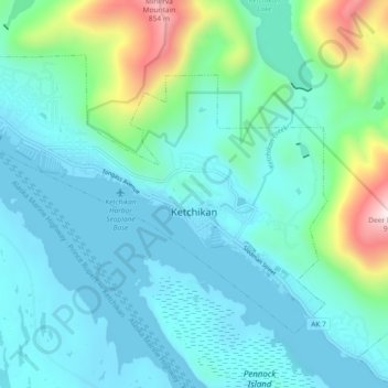
Nom : Carte topographique Ketchikan, altitude, relief.
Lieu : Ketchikan, Ketchikan Gateway, Alaska, 99901, United States (55.32653 -131.70734 55.36437 -131.61494)
Altitude moyenne : 149 m
Altitude minimum : -2 m
Altitude maximum : 848 m
Due to its steep and forested terrain, Ketchikan is long and narrow with much of the built-up area being located along, or no more than a few city blocks from, the waterfront. Elevations of inhabited areas range from just above sea level to about 300 feet (91 m). Deer Mountain, a 3,001-foot (915 m) peak, rises immediately east of the city's downtown area.
Autres cartes topographiques
Cliquez sur une carte pour visualiser sa topographie, son altitude et son relief.
Juno Mountain
United States > Alaska > Ketchikan Gateway
Juno Mountain, Ketchikan Gateway, Alaska, 99901, United States
Altitude moyenne : 438 m
Mud Bay
United States > Alaska > Ketchikan Gateway
Mud Bay, Ketchikan Gateway, Alaska, 99928, United States
Altitude moyenne : 115 m
Marten River
United States > Alaska > Ketchikan Gateway
Marten River, Ketchikan Gateway, Alaska, United States
Altitude moyenne : 207 m
Whitman Lake
United States > Alaska > Ketchikan Gateway
Whitman Lake, Ketchikan Gateway, Alaska, United States
Altitude moyenne : 313 m
Herring Cove
United States > Alaska > Ketchikan Gateway
Herring Cove, Ketchikan Gateway, Alaska, United States
Altitude moyenne : 157 m