
Faire un don
Équipez-vous pour votre prochaine aventure :
En tant que Partenaire Amazon, ce site perçoit une commission sur les achats éligibles sans surcoût pour vous.
Carte topographique Wilmington
Cliquez sur la carte pour afficher l’altitude.
Faire un don
Équipez-vous pour votre prochaine aventure :
En tant que Partenaire Amazon, ce site perçoit une commission sur les achats éligibles sans surcoût pour vous.
Wilmington
Wilmington experiences a humid continental climate (Koppen Dfb) with warm, humid summers and cold (sometimes severely cold) winters. While snowfall can vary greatly from year to year in nearby towns like Bennington and Brattleboro, Wilmington's snowfall is consistently heavy each year because of its elevation in the Green Mountains' high country.
Faire un don
Équipez-vous pour votre prochaine aventure :
En tant que Partenaire Amazon, ce site perçoit une commission sur les achats éligibles sans surcoût pour vous.
À propos de cette carte
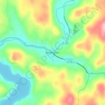
Nom : Carte topographique Wilmington, altitude, relief.
Lieu : Wilmington, Windham County, Vermont, 05363, United States (42.84852 -72.89102 42.88852 -72.85102)
Altitude moyenne : 515 m
Altitude minimum : 441 m
Altitude maximum : 620 m
Faire un don
Équipez-vous pour votre prochaine aventure :
En tant que Partenaire Amazon, ce site perçoit une commission sur les achats éligibles sans surcoût pour vous.