
Faire un don
Équipez-vous pour votre prochaine aventure :
En tant que Partenaire Amazon, ce site perçoit une commission sur les achats éligibles sans surcoût pour vous.
Carte topographique Quinwood
Cliquez sur la carte pour afficher l’altitude.
Faire un don
Équipez-vous pour votre prochaine aventure :
En tant que Partenaire Amazon, ce site perçoit une commission sur les achats éligibles sans surcoût pour vous.
Quinwood
With the elevation and location on a western facing slope, Quinwood can easily see significant amounts of snowfall when winds from the northwest carry moisture from the great lakes and ride up the mountains. This event is called orographic lift. Snowfall amounts over one foot are very common during these events. In 2012, Hurricane Sandy left 29 inches (74 cm) of snow in Quinwood.
Faire un don
Équipez-vous pour votre prochaine aventure :
En tant que Partenaire Amazon, ce site perçoit une commission sur les achats éligibles sans surcoût pour vous.
À propos de cette carte
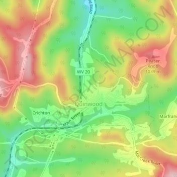
Nom : Carte topographique Quinwood, altitude, relief.
Altitude moyenne : 939 m
Altitude minimum : 827 m
Altitude maximum : 1 059 m
Faire un don
Équipez-vous pour votre prochaine aventure :
En tant que Partenaire Amazon, ce site perçoit une commission sur les achats éligibles sans surcoût pour vous.