
Faire un don
Équipez-vous pour votre prochaine aventure :
En tant que Partenaire Amazon, ce site perçoit une commission sur les achats éligibles sans surcoût pour vous.
Carte topographique Morava
Cliquez sur la carte pour afficher l’altitude.
Faire un don
Équipez-vous pour votre prochaine aventure :
En tant que Partenaire Amazon, ce site perçoit une commission sur les achats éligibles sans surcoût pour vous.
Morava
The Morava originates in the territory of Dolní Morava in the Králický Sněžník Mountains, on the slope of the Králický Sněžník mountain at an elevation of 1,371 m (4,498 ft), not far from the border with Poland. The lowlands formed by the river are the Upper Morava Valley and then the Lower Morava Valley in Moravia, the Morava Field or Marchfeld in Lower Austria, and the Záhorie Lowland in Slovakia. The latter three are actually continuous parts of one large basin, forming a major part of the Vienna Basin.
Faire un don
Équipez-vous pour votre prochaine aventure :
En tant que Partenaire Amazon, ce site perçoit une commission sur les achats éligibles sans surcoût pour vous.
À propos de cette carte
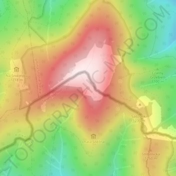
Nom : Carte topographique Morava, altitude, relief.
Altitude moyenne : 1 172 m
Altitude minimum : 899 m
Altitude maximum : 1 424 m
Faire un don
Équipez-vous pour votre prochaine aventure :
En tant que Partenaire Amazon, ce site perçoit une commission sur les achats éligibles sans surcoût pour vous.