
Faire un don
Équipez-vous pour votre prochaine aventure :
En tant que Partenaire Amazon, ce site perçoit une commission sur les achats éligibles sans surcoût pour vous.
Carte topographique Page
Cliquez sur la carte pour afficher l’altitude.
Faire un don
Équipez-vous pour votre prochaine aventure :
En tant que Partenaire Amazon, ce site perçoit une commission sur les achats éligibles sans surcoût pour vous.
Page
Unlike other cities in the area, Page was founded in 1957 as a housing community for workers and their families during the construction of nearby Glen Canyon Dam on the Colorado River. Its 17-square-mile (44 km2) site was obtained in a land exchange with the Navajo Nation. The city is perched atop Manson Mesa at an elevation of 4,300 feet (1,300 m) above sea level and 600 feet (180 m) above Lake Powell.
Faire un don
Équipez-vous pour votre prochaine aventure :
En tant que Partenaire Amazon, ce site perçoit une commission sur les achats éligibles sans surcoût pour vous.
À propos de cette carte
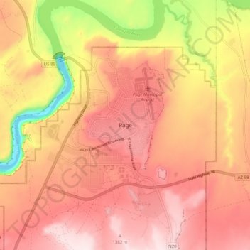
Nom : Carte topographique Page, altitude, relief.
Lieu : Page, Coconino County, Arizona, 86040-0418, United States (36.87483 -111.49729 36.95483 -111.41729)
Altitude moyenne : 1 242 m
Altitude minimum : 949 m
Altitude maximum : 1 403 m
Faire un don
Équipez-vous pour votre prochaine aventure :
En tant que Partenaire Amazon, ce site perçoit une commission sur les achats éligibles sans surcoût pour vous.