
Carte topographique Manalapan Township
Carte interactive
Cliquez sur la carte pour afficher l’altitude.
Manalapan Township
According to the United States Census Bureau, the township had a total area of 30.839 square miles (79.873 km2), including 30.607 square miles (79.271 km2) of land and 0.232 square miles (0.602 km2) of water (0.75%). The township has an elevation of 82 feet (25 m).
À propos de cette carte
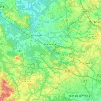
Nom : Carte topographique Manalapan Township, altitude, relief.
Altitude moyenne : 41 m
Altitude minimum : 12 m
Altitude maximum : 104 m