Géolocaliser

Carte topographique Inzing

Cliquez sur la carte pour afficher l’altitude.

À propos de cette carte

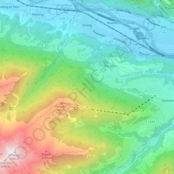
Nom : Carte topographique Inzing, altitude, relief.

Lieu : Inzing, Bezirk Innsbruck-Land, Region Innsbruck, Tyrol, 6401, Autriche (47.21663 11.12144 47.28166 11.22469)

Altitude moyenne : 1 172 m

Altitude minimum : 590 m

Altitude maximum : 2 621 m

Autres cartes topographiques

Cliquez sur une carte pour visualiser sa topographie, son altitude et son relief.

Volderwald

Autriche > Tyrol > Bezirk Innsbruck-Land

Altitude moyenne : 758 m

Serles

Autriche > Tyrol > Bezirk Innsbruck-Land > Fulpmes

Le Serles (aussi appelé Waldrastspitze) est une montagne culminant à 2 717 m d'altitude dans les Alpes de Stubai.

Altitude moyenne : 2 036 m

Sagl

Autriche > Tyrol > Bezirk Innsbruck-Land > Telfs

Altitude moyenne : 855 m

Stubaital

Autriche > Tyrol > Bezirk Innsbruck-Land > Fulpmes

Altitude moyenne : 1 547 m

Obern

Autriche > Tyrol > Bezirk Innsbruck-Land > Schmirn

Altitude moyenne : 1 987 m

Sonnalm

Autriche > Tyrol > Bezirk Innsbruck-Land > Natters

Altitude moyenne : 754 m

Medraz

Autriche > Tyrol > Bezirk Innsbruck-Land > Fulpmes

Altitude moyenne : 1 277 m

Praxmar

Autriche > Tyrol > Bezirk Innsbruck-Land

Altitude moyenne : 2 078 m

Vinaders

Autriche > Tyrol > Bezirk Innsbruck-Land > Gries am Brenner

Altitude moyenne : 1 611 m

Schmirn

Autriche > Tyrol > Bezirk Innsbruck-Land > Gemeinde Schmirn

Altitude moyenne : 1 890 m

Équipez-vous pour votre prochaine aventure :

🧳Sacs de voyage outdoor - Transport du matériel d’aventure
🕶️Lunettes de soleil randonnée - Protection UV pour la montagne et la marche
🧺Serviette Microfibre - Séchage ultra-rapide et encombrement minimal
🧥Polaires de randonnée - Isolation thermique légère
🧴Crème Solaire Sport - Haute protection résistante à la transpiration pour les sommets

En tant que Partenaire Amazon, ce site perçoit une commission sur les achats éligibles sans surcoût pour vous.