
Faire un don
Équipez-vous pour votre prochaine aventure :
En tant que Partenaire Amazon, ce site perçoit une commission sur les achats éligibles sans surcoût pour vous.
Carte topographique Cosgrove
Cliquez sur la carte pour afficher l’altitude.
Faire un don
Équipez-vous pour votre prochaine aventure :
En tant que Partenaire Amazon, ce site perçoit une commission sur les achats éligibles sans surcoût pour vous.
À propos de cette carte
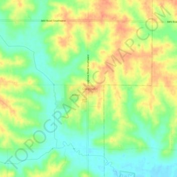
Nom : Carte topographique Cosgrove, altitude, relief.
Lieu : Cosgrove, Johnson County, Iowa, 52244, United States (41.62279 -91.75573 41.66279 -91.71573)
Altitude moyenne : 228 m
Altitude minimum : 206 m
Altitude maximum : 251 m
Faire un don
Équipez-vous pour votre prochaine aventure :
En tant que Partenaire Amazon, ce site perçoit une commission sur les achats éligibles sans surcoût pour vous.
Autres cartes topographiques
Cliquez sur une carte pour visualiser sa topographie, son altitude et son relief.
Iowa City
United States > Iowa > Johnson County
The elevation at the Iowa City Municipal Airport is 668 ft (203.6 m) above sea level.
Altitude moyenne : 216 m
North Liberty
United States > Iowa > Johnson County
North Liberty is located on the Iowan erosion surface. Drivers on I-380 experience an abrupt transition from the muted topography of the Iowan surface to the rolling hills of the Southern Iowa drift plain, four miles south of North Liberty.
Altitude moyenne : 235 m
Faire un don
Équipez-vous pour votre prochaine aventure :
En tant que Partenaire Amazon, ce site perçoit une commission sur les achats éligibles sans surcoût pour vous.
Iowa City
United States > Iowa > Johnson County
The elevation at the Iowa City Municipal Airport is 668 ft (204 m) above sea level.
Altitude moyenne : 216 m
Iowa City
United States > Iowa > Johnson County
The elevation at the Iowa City Municipal Airport is 668 ft (204 m) above sea level.
Altitude moyenne : 216 m
Faire un don
Équipez-vous pour votre prochaine aventure :
En tant que Partenaire Amazon, ce site perçoit une commission sur les achats éligibles sans surcoût pour vous.
Iowa City
United States > Iowa > Johnson County
The elevation at the Iowa City Municipal Airport is 668 ft (204 m) above sea level.
Altitude moyenne : 216 m
North Liberty
United States > Iowa > Johnson County
North Liberty is located on the Iowan erosion surface. Drivers on I-380 experience an abrupt transition from the muted topography of the Iowan surface to the rolling hills of the Southern Iowa drift plain, four miles south of North Liberty.
Altitude moyenne : 235 m
Faire un don
Équipez-vous pour votre prochaine aventure :
En tant que Partenaire Amazon, ce site perçoit une commission sur les achats éligibles sans surcoût pour vous.