
Faire un don
Équipez-vous pour votre prochaine aventure :
En tant que Partenaire Amazon, ce site perçoit une commission sur les achats éligibles sans surcoût pour vous.
Carte topographique Zamboanga City
Cliquez sur la carte pour afficher l’altitude.
Faire un don
Équipez-vous pour votre prochaine aventure :
En tant que Partenaire Amazon, ce site perçoit une commission sur les achats éligibles sans surcoût pour vous.
Zamboanga City
The overall topography of the city could be described as rolling to very steep. There are some flat lands, mostly narrow strips along the east coast. The urban center is mostly flat with a gentle slope to the interior, ranging from 0 to 3%. The highest registered elevation is 1,200 metres. In terms of slope, a large portion of Zamboanga City, about 38,000 hectares, have slopes ranging from 18 to 30%. Another 26,000 hectares have been described as having slopes of less than 3% while about 37% of the area or a total of 52,000 hectares have slopes ranging from 30% to more than 50%.
Faire un don
Équipez-vous pour votre prochaine aventure :
En tant que Partenaire Amazon, ce site perçoit une commission sur les achats éligibles sans surcoût pour vous.
À propos de cette carte
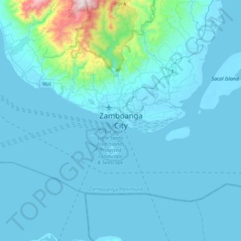
Nom : Carte topographique Zamboanga City, altitude, relief.
Lieu : Zamboanga City, Zamboanga Peninsula, 7000, Philippines (6.74460 121.91637 7.06460 122.23637)
Altitude moyenne : 83 m
Altitude minimum : -2 m
Altitude maximum : 1 201 m
Faire un don
Équipez-vous pour votre prochaine aventure :
En tant que Partenaire Amazon, ce site perçoit une commission sur les achats éligibles sans surcoût pour vous.