
Carte topographique Puducherry Taluk
Carte interactive
Cliquez sur la carte pour afficher l’altitude.
À propos de cette carte
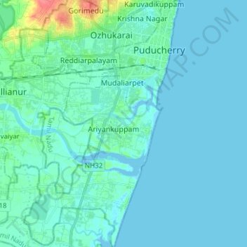
Nom : Carte topographique Puducherry Taluk, altitude, relief.
Lieu : Puducherry Taluk, Puducherry district, Puducherry, India (11.83638 79.76216 11.95864 79.84102)
Altitude moyenne : 6 m
Altitude minimum : -5 m
Altitude maximum : 54 m
Autres cartes topographiques
Cliquez sur une carte pour visualiser sa topographie, son altitude et son relief.
Puducherry
India > Puducherry > Puducherry Taluk
Puducherry, Puducherry Taluk, Puducherry District, Puducherry, 605001, India
Altitude moyenne : 10 m
Bahour
India > Puducherry > Bahour Taluk
Bahour, Bahour Taluk, Puducherry District, Puducherry, 607402, India
Altitude moyenne : 9 m
Kalapet
India > Puducherry > Ozhukarai Taluk
Kalapet, Ozhukarai Taluk, Puducherry District, Puducherry, 605014, India
Altitude moyenne : 14 m
Oulgaret
India > Puducherry > Ozhukarai Taluk > Oulgaret
Oulgaret, Ozhukarai Taluk, Puducherry district, Puducherry, 605005, India
Altitude moyenne : 18 m
Bahour Taluk
Bahour Taluk, Puducherry District, Puducherry, India
Altitude moyenne : 7 m
Yanam
India > Puducherry > Yanam Taluk
Yanam, Yanam Taluk, Yanam District, Puducherry, 533464, India
Altitude moyenne : 5 m