
Carte topographique Nansana
Carte interactive
Cliquez sur la carte pour afficher l’altitude.
À propos de cette carte
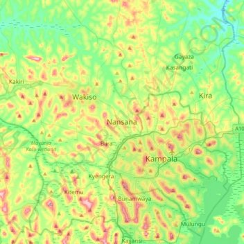
Nom : Carte topographique Nansana, altitude, relief.
Lieu : Nansana, Wakiso, Central Region, Uganda (0.20582 32.36923 0.52582 32.68923)
Altitude moyenne : 1 172 m
Altitude minimum : 1 093 m
Altitude maximum : 1 324 m
Nansana is located on the main highway between Kampala and Hoima, the Kampala-Hoima Road. The town is located approximately 12 kilometres (7 mi), by road, north-west of Kampala, Uganda's capital and largest city. This is approximately 8 kilometres (5 mi), by road, south of Wakiso, the location of the district headquarters. The coordinates of the town are 0°21'50.0"N, 32°31'43.0"E (Latitude:0.363889; Longitude:32.528611). Nansana sits at an average elevation of 1,191 metres (3,907 ft), above mean sea level.
Autres cartes topographiques
Cliquez sur une carte pour visualiser sa topographie, son altitude et son relief.