Géolocaliser

Carte topographique Großer Feldberg

Cliquez sur la carte pour afficher l’altitude.

Großer Feldberg

The Großer Feldberg ('Great Field Mountain') is, at a height of 879.5 metres, the highest elevation of the Taunus mountains, and of the entire Rhenish Massif. It is situated in the Hochtaunuskreis district in Hesse, Germany.

Wikipedia (CC-BY-SA 3.0)

À propos de cette carte

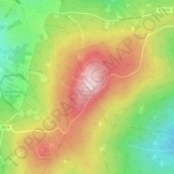
Nom : Carte topographique Großer Feldberg, altitude, relief.

Lieu : Großer Feldberg, Schmitten im Taunus, Hochtaunuskreis, Hesse, 61389, Germany (50.23177 8.45678 50.23187 8.45688)

Altitude moyenne : 716 m

Altitude minimum : 549 m

Altitude maximum : 884 m

Équipez-vous pour votre prochaine aventure :

🧥Polaires de randonnée - Isolation thermique légère
🚥Lumières Vélo LED - Visibilité et sécurité pour les retours tardifs
📍GPS outdoor - Appareils GPS robustes pour activités outdoor
🔥Pierre à Feu (Firesteel) - Allumez un feu dans toutes les conditions météo
👟Chaussures de Trail - Accroche maximale pour courir sur terrains techniques

En tant que Partenaire Amazon, ce site perçoit une commission sur les achats éligibles sans surcoût pour vous.