Géolocaliser
👉 Easily get elevation data in JSON, GeoTIFF and KML formats using Elevation API
Merci de soutenir ce site ❤️
Faire un don
🎯 Votre prochain emploi est peut-être à un message près : emploichat.fr

Carte topographique Hockering

Cliquez sur la carte pour afficher l’altitude.

👉 Easily get elevation data in JSON, GeoTIFF and KML formats using Elevation API
Merci de soutenir ce site ❤️
Faire un don
🎯 Votre prochain emploi est peut-être à un message près : emploichat.fr

À propos de cette carte

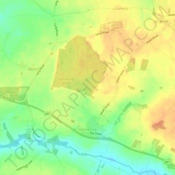
Nom : Carte topographique Hockering, altitude, relief.

Lieu : Hockering, Breckland District, Norfolk, England, United Kingdom (52.66855 1.04856 52.69820 1.10203)

Altitude moyenne : 49 m

Altitude minimum : 28 m

Altitude maximum : 64 m

Autres cartes topographiques

Cliquez sur une carte pour visualiser sa topographie, son altitude et son relief.

Sporle

United Kingdom > England > Norfolk > Breckland District

Altitude moyenne : 72 m

Drymere

United Kingdom > England > Norfolk > Breckland District

Altitude moyenne : 36 m

Eccles

United Kingdom > England > Norfolk > Breckland District

Altitude moyenne : 35 m

Wilby

United Kingdom > England > Norfolk > Breckland District

Altitude moyenne : 36 m

Roudham

United Kingdom > England > Norfolk > Breckland District > Bridgham

Altitude moyenne : 31 m

Thuxton

United Kingdom > England > Norfolk > Breckland District

Altitude moyenne : 46 m

Illington

United Kingdom > England > Norfolk > Breckland District

Altitude moyenne : 35 m

Weeting

United Kingdom > England > Norfolk > Breckland District

Altitude moyenne : 14 m

Northacre

United Kingdom > England > Norfolk > Breckland District > Caston

Altitude moyenne : 50 m

Merci de soutenir ce site ❤️
Faire un don
🎯 Votre prochain emploi est peut-être à un message près : emploichat.fr

Rushford

United Kingdom > England > Norfolk > Breckland District

Altitude moyenne : 29 m

Merci de soutenir ce site ❤️
Faire un don
🎯 Votre prochain emploi est peut-être à un message près : emploichat.fr

Équipez-vous pour votre prochaine aventure :

🪙Couverture de Survie - Protection thermique d'urgence indispensable
🦯Bâtons de randonnée - Bâtons télescopiques pour stabilité et réduction de l’effort
👟Semelles Amortissantes - Confort accru pour les marches sur sols durs ou caillouteux
Montres altimètre - Montres avec altimètre pour mesurer altitude et dénivelé
🌍Équipement d’exploration - Préparer des aventures en terrain inconnu

En tant que Partenaire Amazon, ce site perçoit une commission sur les achats éligibles sans surcoût pour vous.