
Faire un don
Équipez-vous pour votre prochaine aventure :
En tant que Partenaire Amazon, ce site perçoit une commission sur les achats éligibles sans surcoût pour vous.
Carte topographique Armoor
Cliquez sur la carte pour afficher l’altitude.
Faire un don
Équipez-vous pour votre prochaine aventure :
En tant que Partenaire Amazon, ce site perçoit une commission sur les achats éligibles sans surcoût pour vous.
Armoor
Topography and Natural Features Armoor is located in the Deccan Plateau, characterized by its rugged terrain and basalt formations, a typical feature of this volcanic plateau region. One of the most notable geographical highlights is the “Navanatha Siddeshwara Temple Hill” – a large hill that not only holds spiritual significance but also provides a scenic view of the town and its surroundings. This hilly terrain, with its rocky outcrops and vegetation, gives the area its distinctive appearance.
Faire un don
Équipez-vous pour votre prochaine aventure :
En tant que Partenaire Amazon, ce site perçoit une commission sur les achats éligibles sans surcoût pour vous.
À propos de cette carte
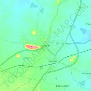
Nom : Carte topographique Armoor, altitude, relief.
Altitude moyenne : 370 m
Altitude minimum : 347 m
Altitude maximum : 463 m
Faire un don
Équipez-vous pour votre prochaine aventure :
En tant que Partenaire Amazon, ce site perçoit une commission sur les achats éligibles sans surcoût pour vous.