
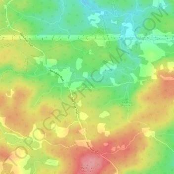
Carte topographique Balmoral
Carte interactive
Cliquez sur la carte pour afficher l’altitude.
À propos de cette carte
Nom : Carte topographique Balmoral, altitude, relief.
Altitude moyenne : 55 m
Altitude minimum : 1 m
Altitude maximum : 112 m
Autres cartes topographiques
Cliquez sur une carte pour visualiser sa topographie, son altitude et son relief.
Flat Rock
Canada > Nova Scotia > Municipality of the County of Richmond > Grand River
Flat Rock, Grand River, Municipality of the County of Richmond, Richmond County, Nova Scotia, Canada
Altitude moyenne : 5 m
Cleveland
Canada > Nova Scotia > Municipality of the County of Richmond
Cleveland, Municipality of the County of Richmond, Richmond County, Nova Scotia, Canada
Altitude moyenne : 40 m
Point Michaud
Canada > Nova Scotia > Municipality of the County of Richmond
Point Michaud, Municipality of the County of Richmond, Richmond County, Nova Scotia, Canada
Altitude moyenne : 12 m
Louisdale
Canada > Nova Scotia > Municipality of the County of Richmond
Louisdale, Municipality of the County of Richmond, Richmond County, Nova Scotia, B0E 1V0, Canada
Altitude moyenne : 26 m