
Carte topographique Mountain Village
Carte interactive
Cliquez sur la carte pour afficher l’altitude.
À propos de cette carte
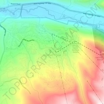
Nom : Carte topographique Mountain Village, altitude, relief.
Altitude moyenne : 2 917 m
Altitude minimum : 2 629 m
Altitude maximum : 3 341 m
Mountain Village is a home rule municipality in San Miguel County, southwestern Colorado. It is located just southwest of Telluride, Colorado in the San Juan Mountains. The elevation of the town rises above Telluride to 9,600 feet. The population was 1,264 at the 2020 census.
Autres cartes topographiques
Cliquez sur une carte pour visualiser sa topographie, son altitude et son relief.
Telluride
United States > Colorado > San Miguel County
Telluride, San Miguel County, Colorado, 81435, United States
Altitude moyenne : 3 125 m
Noel
United States > Colorado > San Miguel County
Noel, San Miguel County, Colorado, United States
Altitude moyenne : 2 774 m
Pandora
United States > Colorado > San Miguel County > Pandora
Pandora, San Miguel County, Colorado, 81435, United States
Altitude moyenne : 3 174 m
Telluride
United States > Colorado > San Miguel County > Telluride
Telluride, San Miguel County, Colorado, 8145, United States
Altitude moyenne : 3 246 m
Imogene Pass
United States > Colorado > San Miguel County
Imogene Pass, San Miguel County, Colorado, 81231, United States
Altitude moyenne : 3 837 m
Telluride Peak
United States > Colorado > San Miguel County
Telluride Peak, San Miguel County, Colorado, 81231, United States
Altitude moyenne : 3 843 m