
Carte topographique Chalkida
Carte interactive
Cliquez sur la carte pour afficher l’altitude.
À propos de cette carte
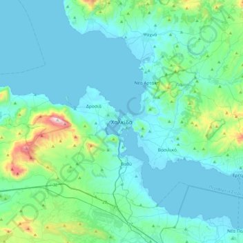
Nom : Carte topographique Chalkida, altitude, relief.
Altitude moyenne : 129 m
Altitude minimum : -1 m
Altitude maximum : 1 006 m
Autres cartes topographiques
Cliquez sur une carte pour visualiser sa topographie, son altitude et son relief.
Agia Irini
Greece > Thessaly and Central Greece > Euboea Regional Unit
Agia Irini, Dirfyon - Messapion Municipality, Euboea Regional Unit, Central Greece, Thessaly and Central Greece, 340 14, Greece
Altitude moyenne : 399 m
Stropones
Greece > Thessaly and Central Greece > Euboea Regional Unit
Stropones, Dirfyon - Messapion Municipality, Euboea Regional Unit, Central Greece, Thessaly and Central Greece, 340 14, Greece
Altitude moyenne : 588 m
Agios
Greece > Thessaly and Central Greece > Euboea Regional Unit
Agios, Dirfyon - Messapion Municipality, Euboea Regional Unit, Central Greece, Thessaly and Central Greece, 344 00, Greece
Altitude moyenne : 502 m
Marmari
Greece > Thessaly and Central Greece > Euboea Regional Unit
Marmari, Karystos Municipality, Euboea Regional Unit, Central Greece, Thessaly and Central Greece, 340 13, Greece
Altitude moyenne : 99 m
Karystos
Greece > Thessaly and Central Greece > Euboea Regional Unit
Karystos, Karystos Municipality, Euboea Regional Unit, Central Greece, Thessaly and Central Greece, 340 01, Greece
Altitude moyenne : 167 m
Κάτω Στενή
Greece > Thessaly and Central Greece > Euboea Regional Unit
Κάτω Στενή, Dirfyon - Messapion Municipality, Euboea Regional Unit, Central Greece, Thessaly and Central Greece, 340 14, Greece
Altitude moyenne : 369 m
Αιδηψός
Greece > Thessaly and Central Greece > Euboea Regional Unit
Αιδηψός, Istiaia-Aidipsos Municipality, Euboea Regional Unit, Central Greece, Thessaly and Central Greece, 343 00, Greece
Altitude moyenne : 113 m
Agios Ioannis
Greece > Thessaly and Central Greece > Euboea Regional Unit
Agios Ioannis, Kymi - Aliveri Anna Municipality, Euboea Regional Unit, Central Greece, Thessaly and Central Greece, 345 00, Greece
Altitude moyenne : 129 m
Xirovrysi
Greece > Thessaly and Central Greece > Euboea Regional Unit > Municipal Unit of Anthidon
Xirovrysi, Municipal Unit of Anthidon, Municipality of Chalkida, Euboea Regional Unit, Central Greece, Thessaly and Central Greece, 341 31, Greece
Altitude moyenne : 15 m
Skyros
Greece > Thessaly and Central Greece > Euboea Regional Unit
Skyros, Euboea Regional Unit, Central Greece, Thessaly and Central Greece, 340 07, Greece
Altitude moyenne : 61 m