
Carte topographique Trenčín
Carte interactive
Cliquez sur la carte pour afficher l’altitude.
Trenčín
Trenčín lies at an altitude of 262 metres (860 ft) above sea level and covers an area of 82 square kilometres (31.7 sq mi). It lies in the Trenčín Basin of north-western Slovakia, which is surrounded by the Strážov Mountains, Považský Inovec and White Carpathians, with the last mentioned being a protected area. The Váh River flows in the north–south axis.
À propos de cette carte
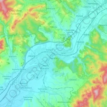
Nom : Carte topographique Trenčín, altitude, relief.
Altitude moyenne : 307 m
Altitude minimum : 191 m
Altitude maximum : 756 m