
Carte topographique Río Cáraba
Carte interactive
Cliquez sur la carte pour afficher l’altitude.
À propos de cette carte
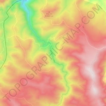
Nom : Carte topographique Río Cáraba, altitude, relief.
Altitude moyenne : 3 391 m
Altitude minimum : 2 993 m
Altitude maximum : 3 613 m
Autres cartes topographiques
Cliquez sur une carte pour visualiser sa topographie, son altitude et son relief.
Paramo de Santurbán
Colombia > Norte de Santander > Silos
Paramo de Santurbán, Silos, Suroccidente, Norte de Santander, Colombia
Altitude moyenne : 3 669 m