
Carte topographique Clarke County
Carte interactive
Cliquez sur la carte pour afficher l’altitude.
À propos de cette carte
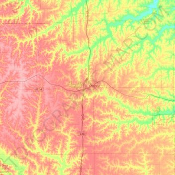
Nom : Carte topographique Clarke County, altitude, relief.
Lieu : Clarke County, Iowa, United States of America (40.89612 -94.01512 41.16218 -93.55756)
Altitude moyenne : 331 m
Altitude minimum : 264 m
Altitude maximum : 377 m
Autres cartes topographiques
Cliquez sur une carte pour visualiser sa topographie, son altitude et son relief.
Bancroft
United States of America > Iowa > Bancroft
Bancroft, Kossuth County, Iowa, United States of America
Altitude moyenne : 354 m
Keystone
United States of America > Iowa > Keystone
Keystone, Benton County, Iowa, 52249, United States of America
Altitude moyenne : 272 m
Woodbury County
United States of America > Iowa
Woodbury County, Iowa, United States of America
Altitude moyenne : 376 m
Agency
United States of America > Iowa > Agency
Agency, Iowa, 52530, United States of America
Altitude moyenne : 243 m
Davis County
United States of America > Iowa
Davis County, Iowa, United States of America
Altitude moyenne : 251 m
Dewar
United States of America > Iowa > Dewar
Dewar, Black Hawk County, Iowa, 50623, United States of America
Altitude moyenne : 279 m
Iowa County
United States of America > Iowa
Iowa County, Iowa, United States of America
Altitude moyenne : 249 m