
Carte topographique Rossel Island
Carte interactive
Cliquez sur la carte pour afficher l’altitude.
À propos de cette carte
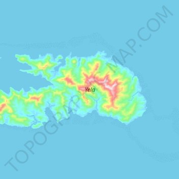
Nom : Carte topographique Rossel Island, altitude, relief.
Lieu : Rossel Island, Milne Bay, Papua Region, Papua New Guinea (-11.42469 153.97222 -11.29017 154.28510)
Altitude moyenne : 36 m
Altitude minimum : -3 m
Altitude maximum : 741 m
The highest elevation is Mount Rossel, near the eastern end of the island, which rises 838 metres (2,749 ft). This precipitous peak has steep ridges extending to the north and west, but it descends in more gentle slopes southeast to Cape Deliverance, the eastern end of the island. The southwest ridge has two conspicuous peaks each 549 metres (1,801 ft) high. The eastern peak, Mount Mo, is flat-topped. The western peak is conical. At the western end of the island is a conspicuous conical peak 347 metres (1,138 ft) high.
Autres cartes topographiques
Cliquez sur une carte pour visualiser sa topographie, son altitude et son relief.
Alotau
Papua New Guinea > Milne Bay > Milne Bay District
Alotau, Milne Bay District, Milne Bay, Southern Region, Papua New Guinea
Altitude moyenne : 134 m
Guasopa
Guasopa, Milne Bay, Southern Region, Papua New Guinea
Altitude moyenne : 7 m
Sololo
Sololo, Milne Bay, Southern Region, Papua New Guinea
Altitude moyenne : 106 m
Sineada
Papua New Guinea > Milne Bay > Milne Bay District
Sineada, Milne Bay District, Milne Bay, Southern Region, Papua New Guinea
Altitude moyenne : 18 m
Tagula
Tagula, Milne Bay, Southern Region, Papua New Guinea
Altitude moyenne : 14 m
Kiriwina Island
Kiriwina Island, Esa’ala District, Milne Bay, Papua Region, Papua New Guinea
Altitude moyenne : 1 m
Misima Island
Misima Island, Misima District, Milne Bay, Papua Region, Papua New Guinea
Altitude moyenne : 27 m
Mudge Island
Mudge Island, Milne Bay, Southern Region, Papua New Guinea
Altitude moyenne : 1 m
Milne Bay District
Papua New Guinea > Milne Bay > Milne Bay District
Milne Bay District, Milne Bay, Southern Region, Papua New Guinea
Altitude moyenne : 82 m
Woodlark Island
Woodlark Island, Losuia District, Milne Bay, Papua Region, Papua New Guinea
Altitude moyenne : 9 m
Goodenough Island
Goodenough Island, Esa’ala District, Milne Bay, Papua Region, Papua New Guinea
Altitude moyenne : 103 m
Gadogadoa Island
Gadogadoa Island, Milne Bay District, Milne Bay, Papua Region, Papua New Guinea
Altitude moyenne : 10 m
Yeina Island
Yeina Island, Misima District, Milne Bay, Papua Region, Papua New Guinea
Altitude moyenne : 16 m
Halfway Rock
Halfway Rock, Losuia District, Milne Bay, Papua Region, Papua New Guinea
Altitude moyenne : 7 m
D'Entrecasteaux Islands
D'Entrecasteaux Islands, Milne Bay, Southern Region, Papua New Guinea
Altitude moyenne : 76 m
Powell Island
Powell Island, Milne Bay District, Milne Bay, Papua Region, Papua New Guinea
Altitude moyenne : 2 m
Dobu Island
Dobu Island, Esa’ala District, Milne Bay, Papua Region, Papua New Guinea
Altitude moyenne : 81 m
Sideia Island
Sideia Island, Milne Bay District, Milne Bay, Papua Region, Papua New Guinea
Altitude moyenne : 30 m
Fergusson Island
Fergusson Island, Esa’ala District, Milne Bay, Papua Region, Papua New Guinea
Altitude moyenne : 98 m