
Carte topographique Karachi
Carte interactive
Cliquez sur la carte pour afficher l’altitude.
À propos de cette carte
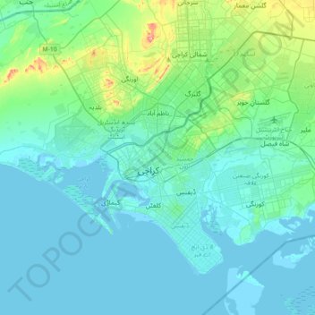
Nom : Carte topographique Karachi, altitude, relief.
Lieu : Karachi, Sindh, 74400, Pakistan (24.69468 66.86071 25.01468 67.18071)
Altitude moyenne : 20 m
Altitude minimum : -4 m
Altitude maximum : 173 m
Karachi lies very close to a major fault line, where the Indian tectonic plate meets the Arabian tectonic plate. Within the city of Karachi are two small ranges: the Khasa Hills and Mulri Hills, which lie in the northwest and act as a barrier between North Nazimabad and Orangi. Karachi's hills are barren and are part of the larger Kirthar Range, and have a maximum elevation of 528 metres (1,732 feet).
Autres cartes topographiques
Cliquez sur une carte pour visualiser sa topographie, son altitude et son relief.
Liquatabad Town
Liquatabad Town, Karachi, Karāchi District, Sindh, 75900, Pakistan
Altitude moyenne : 25 m