
Carte topographique Manger
Carte interactive
Cliquez sur la carte pour afficher l’altitude.
À propos de cette carte
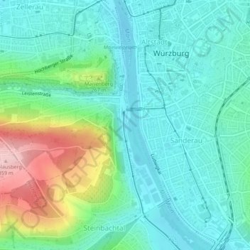
Nom : Carte topographique Manger, altitude, relief.
Lieu : Manger, 9, Würzburg, Bavaria, 97082, Germany (49.78459 9.92524 49.78469 9.92534)
Altitude moyenne : 216 m
Altitude minimum : 166 m
Altitude maximum : 362 m
Autres cartes topographiques
Cliquez sur une carte pour visualiser sa topographie, son altitude et son relief.
Kapitelshöfe
Kapitelshöfe, Würzburg Altstadt, Würzburg, Bavaria, 97070, Germany
Altitude moyenne : 224 m
Marienberg
Marienberg, Würzburg, Lower Franconia, Bavaria, 97082, Germany
Altitude moyenne : 214 m