
Carte topographique Armenia
Carte interactive
Cliquez sur la carte pour afficher l’altitude.
Armenia
Armenia has a territorial area of 29,743 square kilometres (11,484 sq mi). The terrain is mostly mountainous, with fast flowing rivers, and few forests. The land rises to 4,090 metres (13,419 feet) above sea level at Mount Aragats, and no point is below 390 metres (1,280 ft) above sea level. Average elevation of the country area is tenth highest in the world and it has 85.9% mountain area, more than Switzerland or Nepal.
À propos de cette carte
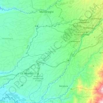
Nom : Carte topographique Armenia, altitude, relief.
Lieu : Armenia, Capital, Quindío, RAP Eje Cafetero, Colombia (4.39574 -75.78940 4.58818 -75.63250)
Altitude moyenne : 1 303 m
Altitude minimum : 1 004 m
Altitude maximum : 2 472 m
Autres cartes topographiques
Cliquez sur une carte pour visualiser sa topographie, son altitude et son relief.