
Carte topographique Buford
Carte interactive
Cliquez sur la carte pour afficher l’altitude.
À propos de cette carte
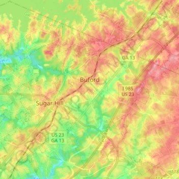
Nom : Carte topographique Buford, altitude, relief.
Lieu : Buford, Gwinnett County, Georgia, United States (34.06061 -84.04827 34.16851 -83.93922)
Altitude moyenne : 340 m
Altitude minimum : 285 m
Altitude maximum : 393 m
Buford is located in both northern Gwinnett County in northern Georgia, with a small portion extending north into Hall County. The city is a suburb within the Atlanta metropolitan area. According to the United States Census Bureau, as of 2010 the city has a total land area of 17.09 square miles (44.26 km2), of which 17.01 square miles (44.06 km2) is land and 0.08 square miles (0.20 km2), or 0.44%, is water. The city's elevation is 1,183 feet (361 m).
Autres cartes topographiques
Cliquez sur une carte pour visualiser sa topographie, son altitude et son relief.
Lilburn
United States > Georgia > Gwinnett County
Lilburn, Gwinnett County, Georgia, United States
Altitude moyenne : 291 m
Norcross
United States > Georgia > Gwinnett County
Norcross, Gwinnett County, Georgia, 30071, United States
Altitude moyenne : 309 m
Northwest Harbor
United States > Georgia > Gwinnett County > Buford
Northwest Harbor, Buford, Gwinnett County, Georgia, 30158, United States
Altitude moyenne : 340 m
Suwanee
United States > Georgia > Gwinnett County
Suwanee, Gwinnett County, Georgia, United States
Altitude moyenne : 311 m
Sugar Hill
United States > Georgia > Gwinnett County
Sugar Hill, Gwinnett County, Georgia, United States
Altitude moyenne : 332 m
Duluth
United States > Georgia > Gwinnett County
Duluth, Gwinnett County, Georgia, United States
Altitude moyenne : 305 m
Sweet Water Park
United States > Georgia > Gwinnett County
Sweet Water Park, Regency Woods, Sweet Water, Gwinnett County, Georgia, United States
Altitude moyenne : 292 m
Snellville
United States > Georgia > Gwinnett County > Snellville
Snellville, Gwinnett County, Georgia, United States
Altitude moyenne : 300 m
Lawrenceville
United States > Georgia > Gwinnett County
Lawrenceville, Gwinnett County, Georgia, United States
Altitude moyenne : 312 m