
Carte topographique Jan Mayen
Carte interactive
Cliquez sur la carte pour afficher l’altitude.
À propos de cette carte
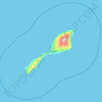
Nom : Carte topographique Jan Mayen, altitude, relief.
Lieu : Jan Mayen, Norway (70.62614 -9.68463 71.35982 -7.31269)
Altitude moyenne : 23 m
Altitude minimum : -1 m
Altitude maximum : 2 211 m
Jan Mayen consists of two geographically distinct parts. Nord-Jan has a round shape and is dominated by the 2,277 m (7,470 ft) high Beerenberg volcano with its large ice cap (114.2 km2 or 44 sq mi), which can be divided into twenty individual outlet glaciers. The largest of those is Sørbreen, with an area of 15 km2 (5.8 sq mi) and a length of 8.7 km (5.41 mi). South-Jan is narrow, comparatively flat and unglaciated. Its highest elevation is Rudolftoppen at 769 m (2,523 ft). The station and living quarters are located on South-Jan. The island lies at the northern end of the Jan Mayen Microcontinent. The microcontinent was originally part of the Greenland Plate, but now forms part of the Eurasian Plate.
Autres cartes topographiques
Cliquez sur une carte pour visualiser sa topographie, son altitude et son relief.
Finnmark
Finnmark, Bamble, Vestfold og Telemark, 3967, Norway
Altitude moyenne : 38 m
Øvre Engesland
Øvre Engesland, Birkenes, Agder, 4768, Norway
Altitude moyenne : 355 m
Gihtsejiegŋa
Gihtsejiegŋa, Nordkalottruta, Tysfjord, Nordland, Norway
Altitude moyenne : 1 096 m
Vetle Skagastølstind
Vetle Skagastølstind, Luster, Sogn og Fjordane, Norway
Altitude moyenne : 1 783 m
Jesus Lever-steinen
Jesus Lever-steinen, Løvstien, Solheims Boretslag, Solheim, Årstad, Gyldenpris, Bergen, Hordaland, 5057, Norway
Altitude moyenne : 100 m
Folgefonna
Folgefonna, Gardshammar, Kvinnherad, Hordaland, Norway
Altitude moyenne : 709 m