
Carte topographique Municipal Unit of Velos
Carte interactive
Cliquez sur la carte pour afficher l’altitude.
À propos de cette carte
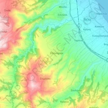
Nom : Carte topographique Municipal Unit of Velos, altitude, relief.
Altitude moyenne : 276 m
Altitude minimum : 0 m
Altitude maximum : 821 m
Autres cartes topographiques
Cliquez sur une carte pour visualiser sa topographie, son altitude et son relief.
Ancient Korinthos
Greece > Peloponnese, Western Greece and the Ionian > Corinthia Regional Unit > Municipal Unit of Corinth
Ancient Korinthos, Municipal Unit of Corinth, Municipality of Corinth, Corinthia Regional Unit, Peloponnese Region, Peloponnese, Western Greece and the Ionian, 200 07, Greece
Altitude moyenne : 101 m
Velo
Greece > Peloponnese, Western Greece and the Ionian > Corinthia Regional Unit > Municipal Unit of Velos
Velo, Municipal Unit of Velos, Municipality of Velo and Vocha, Corinthia Regional Unit, Peloponnese Region, Peloponnese, Western Greece and the Ionian, 200 02, Greece
Altitude moyenne : 50 m
Municipality of Nemea
Greece > Peloponnese, Western Greece and the Ionian > Corinthia Regional Unit
Municipality of Nemea, Corinthia Regional Unit, Peloponnese Region, Peloponnese, Western Greece and the Ionian, 205 00, Greece
Altitude moyenne : 461 m
Municipal Unit of Loutraki - Perachora
Greece > Peloponnese, Western Greece and the Ionian > Corinthia Regional Unit
Municipal Unit of Loutraki - Perachora, Loutraki-Perachora-Agioi Theodoroi Municipality, Corinthia Regional Unit, Peloponnese Region, Peloponnese, Western Greece and the Ionian, Greece
Altitude moyenne : 170 m
Municipal Unit of Sikyona
Greece > Peloponnese, Western Greece and the Ionian > Corinthia Regional Unit
Municipal Unit of Sikyona, Municipality of Sikyona, Corinthia Regional Unit, Peloponnese Region, Peloponnese, Western Greece and the Ionian, Greece
Altitude moyenne : 478 m
Corinth
Greece > Peloponnese, Western Greece and the Ionian > Corinthia Regional Unit
Corinth, Municipal Unit of Corinth, Municipality of Corinth, Corinthia Regional Unit, Peloponnese Region, Peloponnese, Western Greece and the Ionian, 201 00, Greece
Altitude moyenne : 185 m
Γεράνεια (Λουτρακίου-Περαχώρας)
Greece > Peloponnese, Western Greece and the Ionian > Corinthia Regional Unit > Municipal Unit of Loutraki - Perachora
Γεράνεια (Λουτρακίου-Περαχώρας), Municipal Unit of Loutraki - Perachora, Loutraki-Perachora-Agioi Theodoroi Municipality, Corinthia Regional Unit, Peloponnese Region, Peloponnese, Western Greece and the Ionian, 203 00, Greece
Altitude moyenne : 390 m