
Carte topographique East Champaran District
Carte interactive
Cliquez sur la carte pour afficher l’altitude.
À propos de cette carte
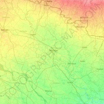
Nom : Carte topographique East Champaran District, altitude, relief.
Lieu : East Champaran District, Bihar, India (26.25457 84.48528 27.02168 85.29697)
Altitude moyenne : 70 m
Altitude minimum : 50 m
Altitude maximum : 101 m
Raxaul is one of the most significant towns of the East Champaran district. By excellence of its topographical area, it is known as the Gateway to Nepal.
Autres cartes topographiques
Cliquez sur une carte pour visualiser sa topographie, son altitude et son relief.
Sonbhadra
India > Bihar > Sonbhadra Banshi Suryapur
Sonbhadra, Sonbhadra Banshi Suryapur, Arwal District, Bihar, 824120, India
Altitude moyenne : 74 m
Pashchim Champāran
Pashchim Champāran, Pashchim Champaran, Bihar, India
Altitude moyenne : 207 m
Sultanganj
India > Bihar > Sultanganj
Sultanganj, Bhagalpur, Bihar, 813223, India
Altitude moyenne : 38 m
Patna
India > Bihar > Patna Rural
Patna, Patna Rural, Patna District, Bihar, 800001, India
Altitude moyenne : 51 m