
Carte topographique Fremont County
Carte interactive
Cliquez sur la carte pour afficher l’altitude.
À propos de cette carte
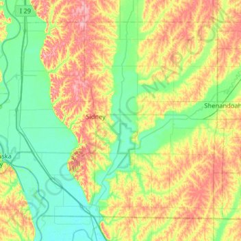
Nom : Carte topographique Fremont County, altitude, relief.
Lieu : Fremont County, Iowa, United States (40.58050 -95.88891 40.90164 -95.37061)
Altitude moyenne : 314 m
Altitude minimum : 274 m
Altitude maximum : 388 m
Autres cartes topographiques
Cliquez sur une carte pour visualiser sa topographie, son altitude et son relief.
Iowa City
United States > Iowa > Johnson County
Iowa City, Johnson County, Iowa, United States
Altitude moyenne : 216 m
Williamsburg
United States > Iowa > Iowa County
Williamsburg, Iowa County, Iowa, 52361, United States
Altitude moyenne : 248 m
Montrose
United States > Iowa > Lee County
Montrose, Lee County, Iowa, United States
Altitude moyenne : 179 m
Miles
United States > Iowa > Jackson County
Miles, Jackson County, Iowa, United States
Altitude moyenne : 248 m
Clive
United States > Iowa > Polk County
Clive, Polk County, Iowa, 50325, United States
Altitude moyenne : 287 m
Rodney
United States > Iowa > Monona County
Rodney, Monona County, Iowa, United States
Altitude moyenne : 343 m
Carmel
United States > Iowa > Sioux County
Carmel, Sioux County, Iowa, United States
Altitude moyenne : 433 m
Westgate
United States > Iowa > Fayette County
Westgate, Fayette County, Iowa, United States
Altitude moyenne : 333 m
Maxwell
United States > Iowa > Story County
Maxwell, Story County, Iowa, United States
Altitude moyenne : 274 m
Cromwell
United States > Iowa > Union County
Cromwell, Union County, Iowa, 50842, United States
Altitude moyenne : 387 m
Wanamaker
United States > Iowa > Ringgold County
Wanamaker, Ringgold County, Iowa, United States
Altitude moyenne : 346 m
Hepburn
United States > Iowa > Page County
Hepburn, Page County, Iowa, United States
Altitude moyenne : 327 m
Cromwell;Cromwell Post Office
United States > Iowa > Union County > Cromwell > Cromwell;Cromwell Post Office
Cromwell;Cromwell Post Office, Cromwell, Union County, Iowa, 50842, United States
Altitude moyenne : 387 m
Mapleton
United States > Iowa > Monona County > Mapleton
Mapleton, Monona County, Iowa, United States
Altitude moyenne : 351 m
Keosauqua
United States > Iowa > Van Buren County > Keosauqua
Keosauqua, Van Buren County, Iowa, United States
Altitude moyenne : 192 m
Northwood
United States > Iowa > Northwood
Northwood, Worth County, Iowa, United States
Altitude moyenne : 371 m
Cumming
United States > Iowa > Cumming
Cumming, Warren County, Iowa, United States
Altitude moyenne : 290 m
Parnell
United States > Iowa > Iowa County
Parnell, Iowa County, Iowa, United States
Altitude moyenne : 253 m
Renwick
United States > Iowa > Humboldt County
Renwick, Humboldt County, Iowa, United States
Altitude moyenne : 347 m
Cedar Rapids
United States > Iowa > Linn County > Cedar Rapids
Cedar Rapids, Linn County, Iowa, United States
Altitude moyenne : 245 m